River System
- by admin
- Oct 21, 2022
- 31
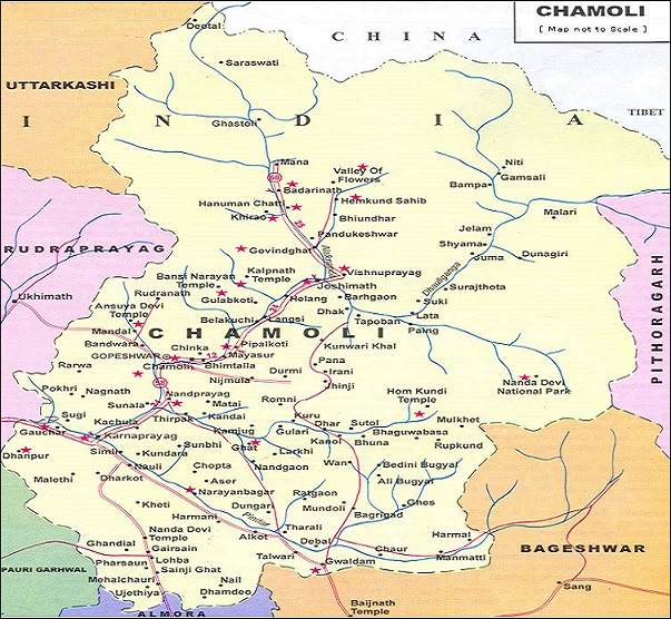
The district is very rich in water resources, given the network of rivers, streams and many rivulets spread across the length and breadth of the district. Chamoli district is criss-crossed by several important rivers and their tributaries. The rivers of Chamoli district, mostly originate from glaciers and generally flow with great force in steep and narrow channels, often resulting in excessive erosion and collapse of the banks. Nearly all of them eventually feed the Alaknanda, one of the two headstreams of the Ganga.
Major Rivers
The major rivers of Chamoli, from the main Alaknanda to its smaller glacier-fed tributaries, are covered below.
Alaknanda
Alaknanda, traversing a distance of 229 kms. before it confluence with Bhagirathi at Devprayag and constituting the Ganga, is the major river. The Alaknanda originates at a height of 3641 meters below Balakun peak 16 km. upstream from Badrinath form the two glaciers of Bhagirath Kharak and Satopanth. The two glaciers rise from the eastern slopes of Chaukhamba (7140 Meters) peak, Badrinath peak and its satellite peaks. These peaks separates the Gangotri group of glaciers in the west. The major portion of the Alaknanda basin falls in Chamoli district. From its source upto Hallang (58 Km), the valley is treated as upper Alaknanda valley. The remaining part of the area is known as lower Alaknanda valley. While moving from its source, the river flows in a narrow deep gorge between the mountain slopes of Alkapuri, from which it derives its name.
In hydrology, the Alaknanda is considered the source stream of the Ganges on account of its greater length and discharge; however, in Hindu mythology and culture, the other headstream, the Bhagirathi, is considered the source stream. There are 37 hydroelectric dams in operation, under construction or planned to harness the energy of the Alaknanda river and its tributaries and generate electricity. As the river flows, the towns along its banks are Badrinath, Vishnuprayag, Joshimath, Chamoli, Nandaprayag, Karnaprayag, Rudraprayag, Srinagar and Devprayag. At each town with suffix prayag, Alaknanda meets another river.
Pindar
Pindar or Pindari River originates from Pindari Glacier in Bageshwar. It passes small towns and villages like Devaal, Tharali, Kulsari, Harmani, Meeng, Narain Bagar, Nalgaon, Simli inhabited in Pindar Valley and finally merges with River Alaknanda at Karnaprayag and thereafter flows as Alaknanda. The Pindar river, before joining Alaknanda, is fed by Kaliganga and Bheriganga.
Saraswati
The Saraswati river has its origination in Deotal and Ragastal nearly 60 kms ahead of Mana, the last Indian village. Locals believe that this is the same river mentioned in the Vedas and Puranas as hidden, and believed to virtually merge at the confluence of Ganga and Yamuna at Prayag. The Saraswati river is visible for a few 100 mts. at Mana village and then merges with Alaknanda. The bubbly frosty waters of the river rage down with tremendous force. Facing the river stands a small Saraswati temple, and a self-proclaimed India's last shop can be spotted too, marked as "Bharat ki aakhri chai ki dukaan".
Dhauli Ganga
The river Dhauliganga rises from the Niti Pass at about 5070 meters. Its valley lies between the Kamet group of peaks in the west and Nanda Devi group in the east. The Dhauli takes a northern course at Malari. Between Malari and Tapovan, it is almost a narrow gorge with perpendicular cliffs on either side several thousand meters high. The Dhauliganga in its turn is fed by Girthi Ganga at Kurkuti and Rishiganga 500 mts. below Reni. It meets Alaknanda at Vishnuprayag above Joshimath.
Nandakini
Nandakini river originates from Semudra Glaciers, Homkund, in the laps of Trishul peak and flows through the western slopes of the Trishul mountains. It joins Alaknanda at Nandprayag.
Rishi Ganga
Originating at Nanda Devi, Rishi Ganga river flows through Uttarkashi district of Uttarakhand before entering Chamoli. Rishi Ganga finds its way through two gorges. The first one is over two ridges, Dharanshi and Malathuni, near Lata village. The second gorge is precariously rocky terrain. Two glaciers are also located along the river, Nanda Devi North and Nanda Devi South. From these two glaciers, several snow-melted streams originate which later merge with Dhauliganga at Raini. Rishi Ganga merges with the Alaknanda river near Joshimath.
Neel Ganga
River Neel Ganga, with its crystal-clear water, flows serenely through a valley near the village of Kulling. Trekkers are often seen resting here before proceeding to destinations in the upper reaches of the hills in this region. The village of Kulling is situated in the Chamoli district of Uttarakhand.
Ram Ganga
Ram Ganga rises from Chorarkhal Dhar in Gairsain block of Chamoli district. Thereafter it flows through Almora, Nainital and Pauri before entering Kalagarh.
Garud Ganga
Garud Ganga flows at 5 km from Pipalkoti at an elevation of 1372 mtr in the Garud valley. It is believed that pebbles found in this river, when kept at home, will ward off poisonous snakes and evil energies. Pregnant women are also said to have a safe delivery, and Nagadosham is believed to be wiped off if one consumes the sacred water of this river. The river runs through Pakhi village, close to the Garuda temple, and then unites with the Alaknanda river. Garuda is said to have done penance here to atone for sins committed by killing snakes. There is a temple dedicated to Lakshmi-Narayana and a separate temple for Garudazhwar closer to the river banks.
Pushpawati
The Pushpawati rises from the East Kamet Glacier, near Rataban, at the base of the Himalayas near the central part of the Garhwal-Tibet border. It flows in a southerly direction to join the Bhyundar Ganga near Ghangaria. The combined stream is thereafter known as the Lakshman Ganga. The latter merges with the Alaknanda river at Govindghat. The Pushpawati drains the Valley of Flowers. The glaciated upper valley of the Pushpawati is U-shaped, and the river flows past thick glacial deposits. A number of glacier-fed streams join it in its upper reaches, and it flows through a gorge in its lower reaches. The upper tracts are under permanent cover of snow, with alpine, sub-alpine and temperate vegetation in the middle and lower catchments. Human habitation here is very sparse. According to legend, the Pandavas, during their years of exile, saw flowers floating down the river and named it Pushpawati.
Laxman Ganga
Laxman Ganga originates from Hemkund Sahib - there is a Laxman temple just behind the Gurdwara from where the river originates. The river is originally known as Bhyundar Ganga and is called Laxman Ganga after it meets the Pushpawati river at Ghangaria. It flows through the Valley of Flowers National Park and merges with Alaknanda at Govindghat.
Dudh Ganga
Dudh Ganga rises from the Kalapani glacier, located on the Vishnudhar ridge. Hence this river is also known as Kalapani Gad. The glacier is about 5 kms long and up to one kilometre wide. The higher elevations of the Dudh Ganga catchment do not bear vegetative cover, as they lie above the snowline, while alpine meadows are found in depressions and on the thick moraine deposits that occur in the upper catchment. Sub-alpine birch and rhododendron forests, and temperate coniferous and deciduous forests, are found in the middle and lower catchments. Human habitation in its valley is very sparse. It finally merges into the Alaknanda river.
Girthi Ganga
Girthi Ganga is an important tributary of the Dhauliganga river in Chamoli Garhwal. It rises from the Kungribingri peak, situated on the border of Chamoli and Tibet, and thereafter descends along a deep gorge. From its origin to the Girthi camping ground the valley bottom is broad; extremely precipitous side walls occur along this river from the camping ground downstream to Girthi Dabhala. During its course it is fed by a large number of glaciers. The valley becomes wide and the gradient gentler in the lower course, and it flows into the Dhauliganga river near Kailashpur.

Sanjay Gaur
A proud resident of Chamoli Garhwal, who wants our state to be famous throughout the world. Everyone should know the diversity in flora, fauna, tourism, mythology and it should become a tourist paradise and people instead of migrating away from it come back to it.
Related Posts
Add Comment
This policy contains information about your privacy. By posting, you are declaring that you understand this policy:
- Your name, rating, website address, town, country, state and comment will be publicly displayed if entered.
- Aside from the data entered into these form fields, other stored data about your comment will include:
- Your IP address (not displayed)
- The time/date of your submission (displayed)
- Your email address will not be shared. It is collected for only two reasons:
- Administrative purposes, should a need to contact you arise.
- To inform you of new comments, should you subscribe to receive notifications.
- A cookie may be set on your computer. This is used to remember your inputs. It will expire by itself.
This policy is subject to change at any time and without notice.
These terms and conditions contain rules about posting comments. By submitting a comment, you are declaring that you agree with these rules:
- Although the administrator will attempt to moderate comments, it is impossible for every comment to have been moderated at any given time.
- You acknowledge that all comments express the views and opinions of the original author and not those of the administrator.
- You agree not to post any material which is knowingly false, obscene, hateful, threatening, harassing or invasive of a person's privacy.
- The administrator has the right to edit, move or remove any comment for any reason and without notice.
Failure to comply with these rules may result in being banned from submitting further comments.
These terms and conditions are subject to change at any time and without notice.
Comments